


UK to install world-first network of underwater wildlife monitoring system
April 3, 2021

London — A world-first network of underwater camera systems is being rolled out across UK Overseas Territories to help protect sea life.
The cameras, which the Government says will make up the world’s largest wildlife-protecting ocean monitoring system, will track fish and other sea creatures in the Caribbean, South Atlantic, Indian, Pacific, and Southern Oceans.
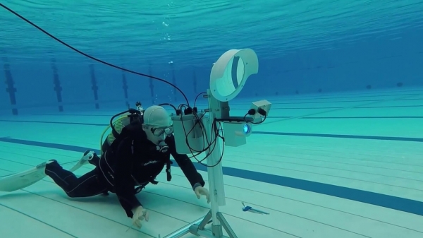
Known as ‘baited remote underwater video systems’ (BRUVS), the cameras will film and analyse data on species including white marlin, silky sharks, black triggerfish, loggerhead turtles, Gould’s squid and sea snakes.
The £2 million network is part of the UK’s Blue Belt programme of marine protected areas around the globe. It is being installed in collaboration with Australian sea-monitoring firm Blue Abacus.
The UKOTs involved in the project are: Anguilla, Ascension Island, British Antarctic Territory, British Indian Ocean Territory, British Virgin Islands, Cayman Islands, Montserrat, Pitcairn, St Helena and Tristan da Cunha.
BRUVS will enable researchers to see below the surface and provide a benchmark of scientific understanding of the marine species within their maritime area, allowing the UKOTs to take more informed decisions about protecting and managing these diverse ecosystems.
The data the cameras collect will provide a standard measure of the status of both open ocean and reef species, letting scientists and the UKOTs set benchmarks for diversity and abundances. This will form valuable information on the many migratory species of open ocean and coastal reef fish species, assist in the management of data-poor fisheries and also improve our understanding of the functioning of pelagic and benthic ecosystems.
Co-founder of Blue Abacus and Professor at the University of Western Australia, Jessica Meeuwig said:
“The world’s tunas, sharks and large reef fish continue to decline in numbers and this trend must be reversed. This programme will give decision makers the evidence they need to act decisively in support of their blue economies.
We are delighted that the UK Government and Overseas Territories support the drive for increased knowledge as we rebuild our oceans. Our refinements to conventional underwater cameras are what makes possible the rollout of this programme over four ocean basins, the largest single such government-supported initiative globally.
We look forward to working with the communities in the Overseas Territories, building on their local knowledge and experience.”
The Global Ocean Wildlife Analysis Network of underwater stereo-baited cameras supports ongoing work amongst the UKOTs, many of which are part of the UK Government Blue Belt Programme, which now covers more than 4 million square kilometres of ocean.
Cefas project lead, Dr Paul Whomersley said:
“The UKOTs are taking a global lead on protecting their oceans and the wildlife and livelihoods that it supports.
Global Ocean Wildlife Analysis Network will provide UKOTs with a world-first network of stereo-baited remote underwater video systems which will enable us all to better understand the biodiversity, functioning and connectivity of these ocean areas, while providing valuable and necessary data to inform and develop UKOTs marine management and protection strategies.”
The project has received support from UK ministers and UKOT representatives.
Timothy Austin, Deputy Director, Research and Assessment, Cayman Islands Department of Environment said:
The Cayman Islands Department of Environment is very excited at the opportunity to participate in the Global Ocean Wildlife Analysis Network that will bring the BRUV network into the Caribbean region for the first time.
Nearshore benthic BRUVs have been an important research tool for informing marine species and protected area management in the Cayman Islands. The opportunity to take this technology further offshore will greatly enhance the Cayman Islands’ ability to implement meaningful and effective conservation regimes for this data limited, poorly understood, but crucially important ecosystem.
Diane Baum, Director of Conservation and Fisheries, Ascension Island Government said:
Ascension is committed to safeguarding its vast 445,000 square kilometer Marine Protected Area, but we recognise how challenging this will be. The support of the Blue Belt Programme and the opportunity to join Global Ocean Wildlife Analysis Network will help us to meet that challenge.
Our previous use of BRUVs has given us an insight into the amazing diversity of our open ocean ecosystems and enabled us to identify hotspots of biodiversity that need special protection. Being part of this initiative will provide Ascension with the information we need to take good local management decisions.
It will also strengthen the network of UK Overseas Territories that is driving improvements in marine conservation at a global scale. Ascension aspires to be the best MPA in the world by basing its management on sound evidence, adopting new technologies and seeking inspirational international partners; this project achieves all three.
Dr Simon Morley, British Antarctic Survey, representing British Antarctic Territory said:
Science is constantly striving to find innovative solutions to monitor the marine environment and these baited cameras offer a solution to help us better understand mid-water communities close to shore along the Antarctic Peninsula. This global network, gives us an excellent opportunity to compare different oceans and understanding the impact of our changing climate.
Over the next few months, complete sets of carbon-fibre stereo-BRUVS and associated equipment will be delivered to the UK Overseas Territories.
This initiative builds on progress to date through the Blue Belt programme to improve our understanding of the marine environment of the UKOTs, and to ensure these diverse ecosystems are protected and managed for future generations. Through the programme, the UKOTs have put in place large-scale marine protection and management measures which cover an area of over 4 million square kilometres.


Facebook Comments